Thursday, March 13, 2014

Spatial Jobs Online News Bulletin Issue 55

Spatial Jobs Online News Bulletin
February 2014 Issue 55
I’m sure many of us have returned to a carpark convinced we know where we left the car only to find it isn’t there.  Of course, it’s been stolen!  We wouldn’t be so stupid as to forget where we put it.  Well forget all you like, as Apple Inc have filed a GPS patent to locate parked vehicles.  OK, it isn’t quite there yet but the sooner it is the sooner we stop having those embarrassing moments and we will never have to wear the shoe leather looking for the car again.

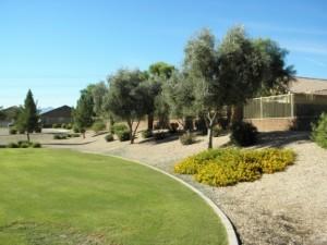
Optimizing water consumption is always a hot topic in Australia, particularly this time of year so it is interesting to read what an American landscaping company is doing in this area.

Do you have any interesting, informative or even funny articles you want to share?  Feel free to send it to info@spatialjobs.com.au
 

GeoInfosys is involved in consultations and promotions to develop new and innovative products, solutions and services in the field of spatial information technology. GeoInfosys promotes information with space and intelligence, provides technology solutions and facilitates technology for better planning and development.
Sustainable development starts at the local level, assessing the resources & issues, both physical and social and empowers locals to participate in the developing the resources and resolving the issues.
                      For more information  www.geoinfosys.org

Articles

Apple files for a GPS Patent to Locate Parked Vehicles


Phoenix landscaping company conducts plant density study to optimize water consumption, tries mobile mapping to collect ‘Big Data’ quickly


Trimble Adds Unmanned Aircraft System to Ag Portfolio for Aerial Mapping


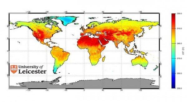
Taking the Earth’s Temperatures by Satellite


Candidate Profile


Quote of the week
Tweet of the week
Horse sense is the thing a horse has which keeps it from betting on people.
W C Fields
@BabySideburns
I’m not giving the kids a timeout. I’m giving myself one. The thought of sitting in a corner and being ignored sounds just heavenly.


Events


Feb 18 Seminar: The 1814 Flinders Map Bicentenary


Feb 26    GeoNext - NSW


Feb  27   QLD GISP-AP Certification - QLD, SICC

 
May 29 - 30

Web and Wireless GIS 2014

Korea


Jobs

Surveyor - Mackay

Mackay, QLD

Manager, Land Information

Canberra, ACT

Information System Project Officer

Perth, WA

GIS Consultant

PSMA Australia, Canberra


Statistics

Employers
1085
Jobs
95
Job Seekers
6939
Resumes
7271
Subscribers
6872


The social bit:

           
This news bulletin has been brought to you by Spatial Jobs Online

If you are interested in having your article, press release or company or personal profile listed at no charge please contact Andrew Luks at info@spatialjobs.com.au

Thanks for your time, I hope you have a great weekend!
Regards

Andrew Luks
Spatial Jobs Online
PO Box 1700 Newcastle NSW 2300

You are receiving this email as an employer who has advertised on the Spatial jobs web site or have subscribed to the Spatial Jobs Newsletter. If you no longer wish to receive emails from Spatial Jobs please click here to Unsubscribe

Tuesday, February 18, 2014

Candidate Profile: Susannah Guenther

My name is Susannah Guenther and I am 21 years old. I live in Adelaide and am currently studying at the University of South Australia. I am doing a Bachelor of Science with a major in Biology and minors in Geoscience and Australian History.

I decided for a future career to pursue Geoscience as it interests me more. The courses I have done in the minor are maps and coordinate systems, environmental remote sensing, landscape fundamentals and soils in the Australian Landscape so far. I still have three subjects to complete the minor this year, my final year, which include geospatial information science and environmental geology. At university I have achieved credits and distinctions in this minor and hope this is of some advantage when being considered for future positions.

In maps and coordinate systems I learnt some skills in making maps using ArcGIS and have some idea of the various coordinate systems in use. Image analysis of terrain, statistics for images, confusion matrices, cluster analysis of remotely sensed imagery and reflectance spectra were some of the skills taught in remote sensing. I also learnt about the various imagery used in remote sensing such as Landsat and Modis imagery. The course also taught various image analysis processes using ERDAS IMAGINE. I also have some skills in soil classification and understanding soil profiles and textures. I can also read a Value Chroma Chart and have some idea of the processes involved in filling out a soil profile record sheet as well as writing field reports. Similar skills were taught in landscape fundamentals. I will be learning new skills in the courses I will be doing and cementing what I have already learnt as the year finishes so my skills will not be limited to what I have listed here.

I have also some skill in biology, basic statistics such as test statistics, communication for information systems and technology and of course some idea of weather and clouds and how that affects soil. Biology skills include working independently on projects, project reports, writing academic essays and presenting on various topics. Communication skills include writing the minutes for meetings, presenting topics to people and writing reports on specific subjects. I have also some skills in microbiology. I have also some understanding of Australian Aboriginal history, the issues they face today and how they protect and interact with the land.
I am looking for a role perhaps in remote sensing and photogrammetry however, roles in soil analysis and classification would also be welcome. Roles that include biology and its processes would also be okay.

At the moment I am hoping to find work in Adelaide as I would like to finish my degree at the University of South Australia rather than transferring to a different university to finish my degree. This is my last year so any positions outside of Adelaide/South Australia after that are welcome.

Contact details:

Mob: 0456104434

Email: catfan2k(at)gmail.com

Tuesday, January 21, 2014

Spatial Jobs Online News Bulletin Issue 54

Spatial Jobs Online News Bulletin
January 2014 Issue 54
Welcome to 2014.  According to Chinese astrology, the Year of the Horse” – to all of the “neighsayers” there are 1,364,520,37++  Chinese who believe in it and have done so for thousands of years.


Included in the prediction for a horse year - It is an excellent year for travel, and the more far away and off the beaten path the better. Energy is high and production is rewarded. Decisive action, not procrastination, brings victory. But you have to act fast in a Horse year.  So it is a good time to get out the maps and/or the GPS and head off into the wide blue yonder.  Or, change your career, so keep an eagle eye on Spatial Jobs Online.


We are always on the lookout for interesting articles and if you have something you want to share, feel free to send it to info@spatialjobs.com.au

http://www.rit.tafensw.edu.au/nec/nrme/giscourses
We’ve got the spotlight on TAFE NSW Riverina Institute, specialists in distance education and GIS courses.


The Institute’s comprehensive courses, specialising in spatial information services using (GIS), are tailored to anyone who is interested in the spatial information sector. The delivery modes specialise in distance-education and on-line, and blended options our available to ensure our students/clients needs are met.  Courses include the use of either ESRI (ArcGIS) software or MapInfo. Student licences are available for both platforms if you do not already have access to software.

Articles


3 Ways to Replace Pen and Paper with Mobile GIS


Candidate Profile

Clayborne Dango
Recent RMIT Graduate


Quote of the week
Tweet of the week

My definition of an intellectual is someone who can listen to the William Tell Overture without thinking of the Lone Ranger.
Billy Connolly
Snorklhuahua @weinerdog4life
One time I threw a boomerang and lost it, now I live in constant fear.


Events


QLD Graduate Surveyors Weekend Seminar - QLD, LSC


Remote Sensing and Earth Observation Fields Seminar - NSW, RSPC


SA Cartography and Map Design Workshop - SA, SICC


Jobs

Manager, Land Information Systems

Canberra, ACT

Senior Engineering Surveyor

Banana Shire Council, QLD

GIS Analyst SDE

Brisbane CBD

Senior Project Manager - Mapping

Brisbane

Construction/Registered/Graduate/Surveyor

B&P Surveys, NSW


Statistics

Employers
918
Jobs
102
Job Seekers
5887
Resumes
6165
Subscribers
6225


The social bit:

           
This news bulletin has been brought to you by Spatial Jobs Online


If you are interested in having your article, press release or company or personal profile listed at no charge please contact Andrew Luks at info@spatialjobs.com.au


Thanks for your time, enjoy the coming week.
Regards

Andrew Luks
Spatial Jobs Online
PO Box 1700 Newcastle NSW 2300

You are receiving this email as an employer who has advertised on the Spatial jobs web site or have subscribed to the Spatial Jobs Newsletter. If you no longer wish to receive emails from Spatial Jobs please click here to Unsubscribe

Wednesday, January 8, 2014

Candidate profile - Clayborne Dango

Clayborne Dango
T: (03) 9467 4699
M: (03) 0435 423 550
E:
claydango(at)gmail.com
PERSONAL SUMMARY

Recent graduate looking for work in the fields of GIS and surveying that utilizes and expands my technical skills of GIS and its’ related forms of technology. Along with a proven academic record, I am highly focused and have a comprehensive knowledge of multiple GIS suites such as ESRI ArcGIS, as well as various surveying techniques. I look to forward to bringing enthusiasm, responsibility, dedication, and an excellent work ethic to an organization.

I am eagerly looking to work for an organization offering continued growth and development opportunities, which will facilitate the application of various skills I have acquired throughout the course of my studies through interesting and creative projects.

ACADEMIC QUALIFICATIONS

RMIT University                                2009 - 2012
Bachelor of Applied Science  (Geomatics)

Parade College                                     2003 - 2008
Victorian Certificate of Education

SUMMARY OF SKILLS DEMONSTRATED

·         Experienced with various GIS software, including, the ESRI suite, ARCview GIS, LISCAD, MapInfo as well as data manipulation of spreadsheets.
·        Studied the various fields of GIS including photogrammetry, remote sensing, aerial mapping, Spatial Information Science (SIS) and satellite image processing.
·         Using tools to merge assorted GIS datasets and create new information or investigate patterns.
·         Meeting clients face to face and demonstrating to them how GIS will fit within their organization to deliver business benefits.
·         Working effectively within a team.
·         Developing and maintaining the structures necessary for GIS data storage.
·         Explaining intricate technical data to colleagues and clients unfamiliar with GIS
·         Delivery of GIS databases and applications.

·         Experienced in land surveying and cadastral law through performing a wide range of various surveys. These included topographic, boundary and subdivision surveys.